


Hurricane Isaias transformed into a monster cyclone over the North Atlantic
Hurricane Isaias transformed into a monster cyclone over the North Atlantic

Chrissy Sexton Wed, October 21, 2026 at 3:36 PM UTC
0
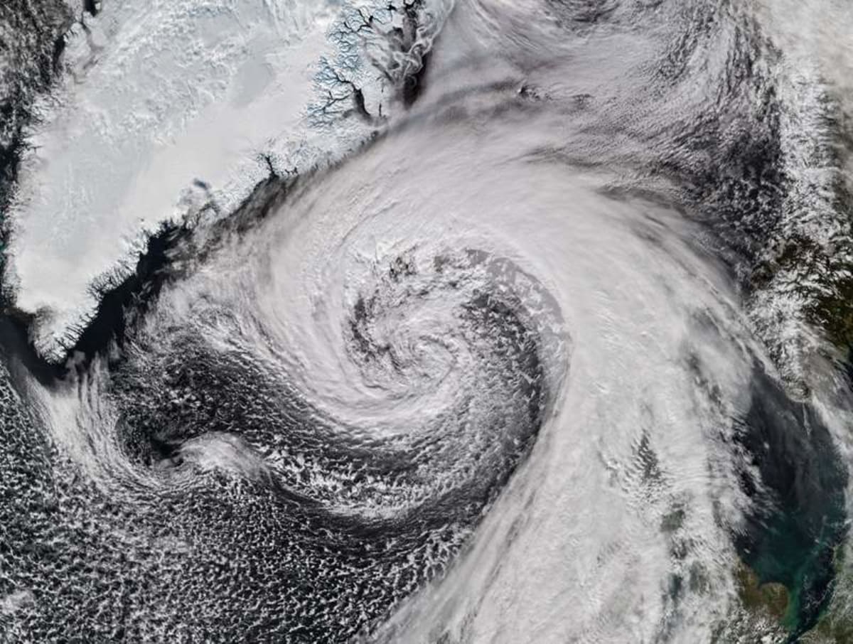
On October 14, 2026, a NASA satellite captured the enormous spiral of clouds surrounding a powerful cyclone near Iceland. Credit: NASA Earth Observatory
Hurricanes are usually associated with warm tropical waters, but their influence can extend far beyond the regions where they first develop.
Some storms travel thousands of miles, changing their structure and gathering new strength as they move into colder environments.
A striking satellite image from NASA Earth Observatory captures one such transformation.
Former Hurricane Isaias, which struck Florida earlier in October 2026, evolved into an exceptionally powerful North Atlantic cyclone before sweeping past Iceland.
The storm brought destructive winds, falling air pressure, and severe weather to parts of northern Europe.
Its remarkable evolution also demonstrated how a fading tropical hurricane can develop into an entirely different kind of weather system.
From Florida to the North Atlantic
Hurricane Isaias made landfall in Florida on October 9 as a Category 2 storm.
It was the only Atlantic hurricane recorded up to that point in the 2026 season.
After battering the U.S. Gulf Coast with heavy rain and strong winds, the system continued across the eastern United States, bringing widespread rainfall to communities along the Eastern Seaboard.
Rather than disappearing after leaving the continent, the remnants of Isaias moved eastward across the North Atlantic.
There, the storm encountered the jet stream, a fast-moving current of air high in the atmosphere that helps steer weather systems across the globe.
As Isaias traveled into cooler northern latitudes, it underwent a dramatic transformation.
The system evolved into an extratropical cyclone, a powerful type of storm that draws much of its energy from temperature differences between air masses.
Unlike tropical hurricanes, which depend on warm ocean waters for their energy, extratropical cyclones can strengthen over colder seas.
A massive storm takes shape
On October 14, the Visible Infrared Imaging Radiometer Suite (VIIRS) aboard the NOAA-21 satellite captured the transformed storm as it brushed past Iceland.
The NASA Earth Observatory image reveals an enormous swirling cloud system stretching across the North Atlantic.
Its distinctive shape reflects the structure of an extratropical cyclone, which often develops sweeping bands of clouds resembling a comma.
These systems form when contrasting air masses interact, creating regions of rising air, changing winds, and falling atmospheric pressure.
The resulting storms can cover vast distances and produce weather conditions ranging from heavy rainfall to powerful winds and snow.
In particularly intense cases, their winds can reach hurricane strength, even though the storms are no longer classified as tropical hurricanes.
An extraordinary drop in air pressure
One of the most remarkable features of the transformed Isaias was the speed at which its atmospheric pressure fell.
During its journey across the Atlantic, the storm’s central pressure dropped by more than 50 hectopascals within just 24 hours.
Advertisement
Meteorologists describe this rapid intensification as explosive cyclogenesis, sometimes called bombogenesis.
The phenomenon occurs when a low-pressure weather system strengthens unusually quickly.
At approximately 60 degrees latitude, a pressure decrease of 24 hectopascals in 24 hours meets the commonly used threshold, although the precise requirement varies with latitude.
Isaias’s pressure decline was roughly twice that benchmark, highlighting the extraordinary intensity of its development.
Some meteorologists suggested that the cyclone may have established a new October record for low atmospheric pressure in Iceland, potentially breaking a record dating to 1963.
Such measurements offer valuable information about the strength of a storm because lower central pressure generally indicates a more intense low-pressure system.
Destructive winds sweep across Iceland
As the cyclone approached Iceland, its powerful circulation generated dangerous winds across the island.
Near Eyjafjallajökull, the volcano in southern Iceland famous for its disruptive 2010 eruption, a wind gust reached approximately 205 kilometers (128 miles) per hour.
That is well above the minimum wind speed associated with a Category 1 hurricane, although the cyclone itself was no longer a tropical hurricane.
On a small island offshore, sustained winds reached 150 kilometers (93 miles) per hour.
The severe conditions were not confined to Iceland’s southern coast. Northern communities also experienced damaging winds, while residents prepared for sleet and snow.
The storm’s influence extended farther east to Scotland, where gusts reached approximately 90 kilometers (55 miles) per hour on October 14.
The rough weather disrupted transportation, forcing the cancellation of several ferry services.
Why former hurricanes can remain dangerous
The transformation of Isaias illustrates an important feature of Atlantic weather.
A hurricane does not necessarily become harmless when it loses its tropical characteristics.
Instead, some tropical cyclones undergo a process known as extratropical transition, during which their circulation becomes increasingly influenced by temperature contrasts and larger atmospheric weather patterns.
Under favorable conditions, these transformed systems can intensify rapidly and produce severe weather far from their original formation regions.
The North Atlantic is particularly well suited to this process because powerful jet stream winds and sharp temperature differences frequently interact over the ocean.
For communities in Iceland, the British Isles, and other parts of northern Europe, these storms can present serious hazards even when their tropical origins are thousands of miles away.
—–
Like what you read? Subscribe to our newsletter for engaging articles, exclusive content, and the latest updates.
Check us out on EarthSnap, a free app brought to you by Eric Ralls and Earth.com.
—–
Source: “AOL Breaking”
